The flow of the jet stream is somewhat like a river – at times, a straight rushing ravine and at other times, a slow twisting meander. It’s almost like the atmosphere is alternately dancing the quickstep or doing a slow waltz. Why does the jet stream change its behavior and how might a warming climate be affecting this central influence on our weather in the U.S.? Let’s take a close look at what’s going on in the atmosphere up above us every day.
Why planes fly faster from west to east – it’s the wind!
 This post is part of a series on
A Summer of Extremes: Confronting the Realities of Climate Change
Subscribe to the series RSS feed.
In mid-latitudes in the northern hemisphere – over most of the lower 48 states – the dominant jet stream is the Polar jet stream. It separates cold air to the north from warm air to the south, and lies five to seven miles above the Earth’s surface with winds reaching more than 200 miles per hour.
With a tail wind like that, it’s no wonder flights from west to east are faster. Flying with the jet stream can decrease fuel consumption and shorten flying times considerably. In fact, pilots seek out the jet stream to either use it or avoid it. Jet streams can be thousands of miles long and hundreds of miles wide, but we usually focus on thin bands of faster-flowing air that influence local weather patterns.
Air flows downhill from the tropics to the poles and then turns east
How does the jet stream form? Well, most of our weather occurs in the very lowest layer of the atmosphere called the “troposphere” where the air is turbulent and mixes rapidly (the Greek word “tropo” means turning). The upper boundary of this part of the atmosphere is higher at the equator than at the poles, simply because warmer air at the equator expands and takes up more room. As a result, air flows downhill from the puffed up warm air at the equator to the compressed cold air at the poles.
In the northern hemisphere as this air flows from equator to pole it is turned to the right because of Earth’s rotation. This resulting west to east flow is known as a jet stream. You can see more thorough explanations of the physics from NOAA’s National Weather Service and from Skeptical Science.
A slowed jet stream meanders like a lazy river
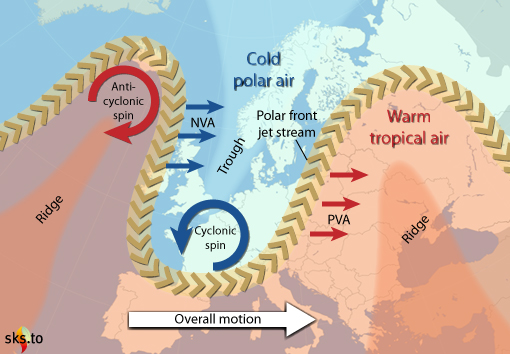
When the Polar jet stream slows down, the wave patterns known as planetary or Rossby waves start to meander and widen, just like a river does when it slows down in its lower reaches. The meanders form large lobes that bring warmer weather much farther north and colder weather much farther south than usual. Low pressure systems form in the southern end of the troughs – these cyclonic or inward-flowing masses of air result in convective storms, heavy rainfall events, and flooding. High pressure systems form in the northern end of the ridges – these anti-cyclonic or outward-flowing masses of air bring hot, dry weather.

The slowing of the west to east flow of the jet stream produces large meandering lobes that can stall, resulting in long periods of unchanging weather. Source: Skeptical Science
The jet stream becomes stuck, leading to extreme weather
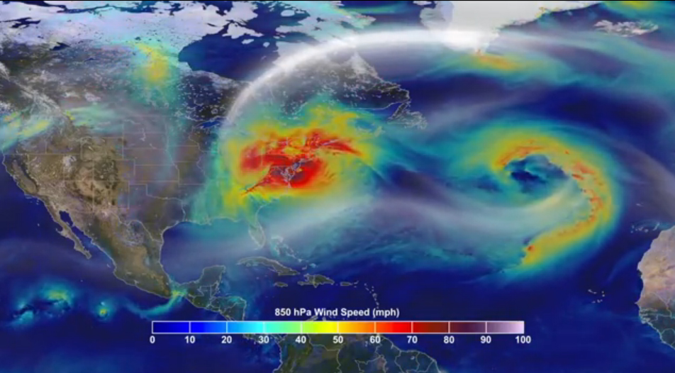
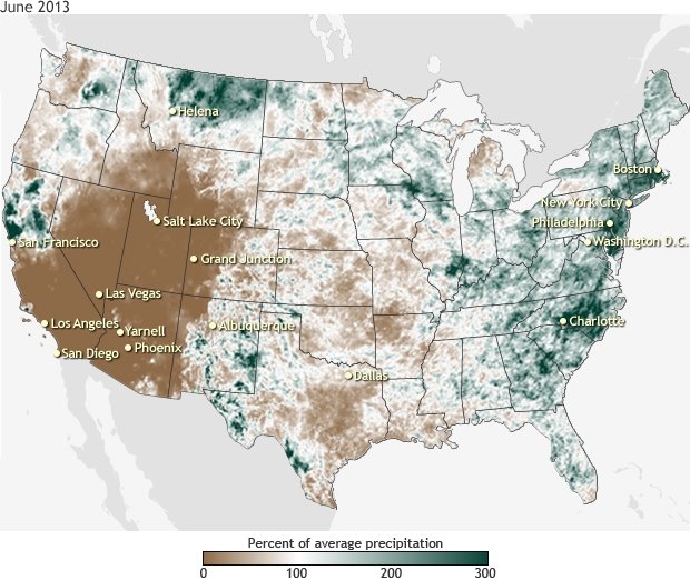
When the jet stream slows down our weather tends to become “stuck” in either of these modes, resulting in long periods of the same patterns of weather that leads to extremes. We saw the consequences of this in June of this year when wildfires raged in the western half of the U.S. while the eastern seaboard was drenched in rain. And in October 2012 Hurricane Sandy took an unusual path through New Jersey when the large loops of the jet stream were stuck, as explained in a blog here.
A recent paper suggests the stalling of these planetary waves could have caused the U.S. heat wave of 2011, the floods in Russia and Pakistan in 2010, and the European heat wave of 2003. It’s not clear yet whether these stalled weather patterns are becoming more frequent and we won’t know until we have longer data sets. However, scientists are currently trying to figure out the most likely cause of a slowdown of the jet stream.

The uncharacteristic north-westerly path of Hurricane Sandy was influenced by a blocking ridge that developed from an unusual jet stream pattern. Source: NASA

A stalled jet stream in June this year resulted in intense dry weather in the west and downpours on the eastern seaboard. Source: NOAA National Climate Data Center
The Arctic “amplification” — a possible explanation for a stalling jet stream?
In recent years the Arctic has warmed at an alarming rate (as was predicted by models) due to strong reinforcing feedbacks in the climate system. With the Arctic warming at twice the pace of the rest of the planet, the temperature contrast between the equator and the poles has decreased. The downhill run of air from equator to pole is not as steep as it was, diminishing the strength of the jet stream and resulting in the large meandering patterns.
Jennifer Francis, a Research Professor at Rutgers University, and Jeff Masters from the Weather Underground explain why this amplification of warming in the Arctic might be an explanation for a weakening jet stream. With her colleague Stephen Vavrus, Francis has also published a paper on the topic. There are other explanations that also consider changes to the heat content of the Arctic ocean as well as the role of increased water vapor transport in the atmosphere, as discussed in an American Geophysical Union blog with Kevin Trenberth. Scientists are still working on the details, but plausible explanations of this “wacky weather” are starting to emerge.
