
Sometimes a visitor’s appreciation of historic sites can benefit from a good dose of imagination. Who doesn’t conjure thousands of soldiers from their mind’s eye on a walk across the battlefield at Gettysburg? But more and more, I find myself imagining not what these places were like in the past, but what will become of them in the future.
Flooding at City Dock in Annapolis, Maryland. Photo: Amy E. McGovern
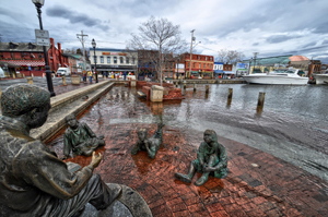
Sea level rise and coastal flooding exacerbated by extreme rainfall events and storms, is perhaps the most obvious threat to our heritage. You can stand on the harbor wall of Annapolis’s bustling City Dock and imagine what it must have been like for the members of the Continental Congress who met there after the American Revolution in the winter of 1783-4; or you can stand there and imagine the historic buildings swamped with water as they were during Hurricane Isabel in 2003.
The City of Annapolis (with support from the National Trust for Historic Preservation) has identified 140 historic buildings at risk from flooding, and the story of growing risk and vulnerability is repeated in historic districts all along America’s coasts. As our planet warms and the climate continues to change, it’s becoming clear that the consequences could be dire for many thousands of historic buildings, archaeological sites and cultural landscapes.
The global average of sea level rise was about 8 inches between 1880 and 2009, a period during which the planet warmed by 1.8 degrees F. As water warms, it expands, and this combined with the melting of land ice including glaciers and polar ice sheets causes sea levels to rise.
The amount the water rises is quite variable from place to place depending on local factors such as land subsidence and groundwater extraction. For example, the 600-mile stretch of the east coast from Cape Hatteras in North Carolina up to Maine has experienced some of the fastest rates of sea level rise anywhere in the world since the 1970s.
Rising sea levels present a direct problem to vulnerable historic structures in coastal communities. Higher seas mean more frequent and severe tidal flooding, increased rates of coastal erosion, and greater storm damage. A new Union of Concerned Scientists analysis of 52 NOAA (National Oceanic and Atmosphere Administration) tide gauges along the East and Gulf coasts shows that many low-lying communities will experience a doubling or tripling of high-tide flooding events within the next 15 years.

Gay Head Light House on Martha’s Vineyard. Photo: Michele Schaffer via Creative Commons
You don’t need to be a climate change expert to understand the risk. You just need to stroll through the historic waterfront neighborhoods of historic towns such as St. Augustine, Florida; Norfolk, Virginia; and Charleston, South Carolina. Downtown Charleston, a world-renowned leader in architectural preservation already experiences around 10 high-tide flooding events annually compared to just two in the 1970s, and conditions are only going to get worse.
Some cities, including parts of Washington D.C., and Annapolis, Maryland, can expect to see 150 to 200 tidal flooding events annually by 2030. Storms can exacerbate the flooding threat. The U.S. Naval Academy in Annapolis, for example, a national historic landmark famous for its Beaux Arts campus buildings, sustained $120 million in flood damage from Hurricane Isabel in 2003.
Coastal erosion and flooding is already causing severe damage to precious historic sites and cultural resources around the U.S. coast. Early Hawaiian sacred sites and prehistoric stone fish-traps on the west coast of the Big Island are under threat, as are ancient shell mounds in the wetlands of southern Florida, colonial districts in Baltimore and Boston, the iconic Gay Head Lighthouse on Martha’s Vineyard, and perhaps most famously, Colonial Jamestown in Virginia.
Last June, arriving early for a climate change roundtable with Secretary of the Interior Sally Jewell at Jamestown, I walked down to the beach of the James River. Where I stood on this rapidly eroding shoreline was literally just spitting distance from the 400-year-old ruins of the old glassblowing works. It was only too easy to imagine the growing threat of flooding and inundation facing this–the first site of English manufacturing in America.

Jamestown, Virginia, viewed from the James River. Photo: Carolyn Conner via Creative Commons
Later that day, Secretary Jewell toured Jamestown and said, “It’s very clear we have global warming and sea level rise and this is a hot spot for it…And what’s at risk is the history of our country… We don’t have very many places in the United States that talk about the super-early history of settlers connecting with the native people of the land, so this is a really an important place.”
While the threat to coastal historic buildings from sea level rise is clear to most people, less thought is given to impacts driven by a changing climate at inland sites. Wildfires are increasingly threatening western sites ranging from the ancient pueblo remains of Bandelier National Monument to the 19th-century wooden buildings of gold rush towns such as Groveland, California, and Virginia City, Montana. Bandelier National Monument was among 17 cases studies the Union of Concerned Scientists wrote about in its May 2014 report, National Landmarks at Risk.
Hotter and drier conditions caused by climate change have been the primary driving factor behind the increasing area burned by large wildfires in the western United States. The length of the wildfire season has increased by more than two months since 1970, and the devastating flash floods that often follow massive wildfires when land has been denuded of trees and vegetation are now a growing risk for archaeological resources in the Southwest.

The Mission at Tumacacori in Arizona. Photo: Ken Lund via Creative Commons
According to the 2014 National Climate Assessment (NCA), there has been a strong trend toward increasing frequency of extreme rainfall events nationwide in recent years.
Heavy downpours have been identified by the National Park Service as a risk factor for adobe structures such as the Mission at Tumacacori in Arizona, while flash floods associated with Hurricane Irene in 2011 brought damage and destruction to many historic covered bridges in upstate New York and Vermont. The Northeast has experienced a greater increase in extreme precipitation since 1958 than any other region of the country, with more than a 70 percent increase in rainfall during the heaviest events.
Less dramatic, but often equally insidious climate impacts have included changes in the freeze-thaw cycle. Managers at Aspet, the New Hampshire home of sculptor Augustus Saint-Gaudens, have sounded the alarm over the damage being done to the house’s brickwork as a result of warmer winters. In winters past, snow could be relied on to cover the ground throughout the winter, whereas now it often melts away before falling again during the season, and multiple freeze-thaw cycles are causing bricks to splinter and shear.
Just from the few examples I’ve mentioned here, it’s clear to see that the impacts of climate change are pervasive. It’s alarming to think, however, that for the country as a whole, we have as yet very little grasp of just how bad the situation is, which sites are most vulnerable or at greatest immediate risk, or what the best solutions are. Obviously we must work to reduce the greenhouse gas emissions that cause climate change, but equally we must begin to prepare much more urgently, not just for the climate impacts that are already becoming manifest, but also for those that are already locked into the system and will be worsening in the coming decades.

Bandelier National Monument. Photo: Sarah Stierch via Creative Commons
Climate resilience will have to become a national priority; and we must allocate the necessary resources to ensuring effective preservation in a changing climate. We need an action agenda for preservation in a changing climate. One that will require a better understanding of which resources are most vulnerable to climate impacts and how climate change is increasing the risks. We’ll also need to evaluate the effectiveness of current preservation strategies and technologies in light of these rapidly changing environmental factors. And significantly, we must find ways to prioritize among at-risk sites given limited available resources. There will be hard choices to make, but if we delay in addressing these issues we will surely regret it.
Right now I can visit the Harriett Tubman Underground Railroad National Monument on the Eastern Shore of the Chesapeake Bay and see a landscape remarkably little changed from when Tubman led scores of her family and neighbors to safety across the marshes. I can see where she lived and worked, and I can imagine the perils she faced when she freed herself and others. Unfortunately, neither does it take much imagination to see that a little more sea level rise could submerge this and many other landscapes of national memory almost entirely.