They say all politics is local and the same could be true about our perspective this time of year when the annual global average temperature numbers are released.
That Map We Probably First Saw on the Classroom Wall
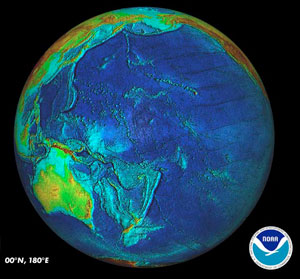
For those of us who grew up in the United States looking at map views on classroom walls, we probably saw maps with North America looming large and filling most of the map. Given the exaggeration of higher latitude land areas such as Greenland or Antarctica in standard map projections, it is no wonder we may have a strange sense of proportion within the world we live. This is why I sometimes like to look at the Pacific view of the world to remind myself that yes indeed, the ocean covers over 70 percent of the Earth’s surface.

View of Earth from the perspective of the Pacific Ocean centered at the equator and the 180 degrees East longitude. Image Credit: National Geophysical Data Center of the National Oceanic and Atmospheric Administration (NOAA).
When we look at the world from this perspective we might get a better sense that even if you add in the land area for Alaska and Hawaii, the land area for the United States is only around 2 percent of the Earth’s surface. Though obvious, it is not always uppermost in our thoughts that what’s happening with the weather or the average temperature in our small backyard of the United States may not be the temperature around the rest of the world.
Where Will 2011 Fit in the Record Books?
As we await the final analysis by research centers that provide annual global average temperature results for 2011, where we live may influence the context within which each of us hears reports of a warmer than average year. For example, this may fall on deaf ears for those living in the northern hemisphere, especially those who live in the areas that experienced the fourth largest November snow extent over the 1966-2011 period. Or the 2011 global temperature may seem reasonable for those that saw signs of unseasonably warm November weather where the eastern half of the United States experienced above normal temperatures.
So far, the official tally for 2011 rests on the January to November temperature averages. Land area was ranked seventh warmest on record, according to the National Oceanic and Atmospheric Administration’s (NOAA) National Climatic Data Center analysis. The ocean area average temperature and combined land plus ocean area average temperature was eleventh warmest over the 117 year period of record.
However, for the continental United States, the January to November period was above normal, but not a top ten record breaker (around twentieth warmest). Over the long run, however, the U.S. trends are in lock-step with the global trends as the last decade was the hottest on record both for the United States and for the world.
We shall soon learn in over a week’s time if these January to November 2011 rankings hold once the December 2011 observations are analyzed. Remember, this is only one year that is being ranked and it is likely the U.S. and global ranks for 2011 are not the same. There is a good chance that the global average temperature for 2011 is within the top 15 warmest years on record, but not likely in the United States. We are, after all, only living in the 2 percent.
Did 2011 seem hotter, average, or cooler than average where you live?
Jan 13, 2012 update: The December data for the continental United States are available. The January to December 2011 national average temperature ranked twenty-second out of 117 years of record.
