
If you’ve been wondering what sea level will look like with ongoing climate change, head to the coast during a “king tide,” the highest tide of the year. This weekend extreme high tides are happening in a number of places along the U.S. East Coast, including Florida, New Jersey, and Maryland. Grab your camera and join the fray!
A refresher on why the tides happen when they do
 Predicting the height of the daily tides at a location is not a trivial task. Tides are a complex interplay of (i) the gravitational attraction and rotation of the Earth, sun, and moon, (ii) oceanic processes like waves and currents, and (iii) the local weather conditions. Combine the first two together and you come up with predictions of tide heights, then add the last one for a bit of randomness and you have the actual tide that occurs on the day.
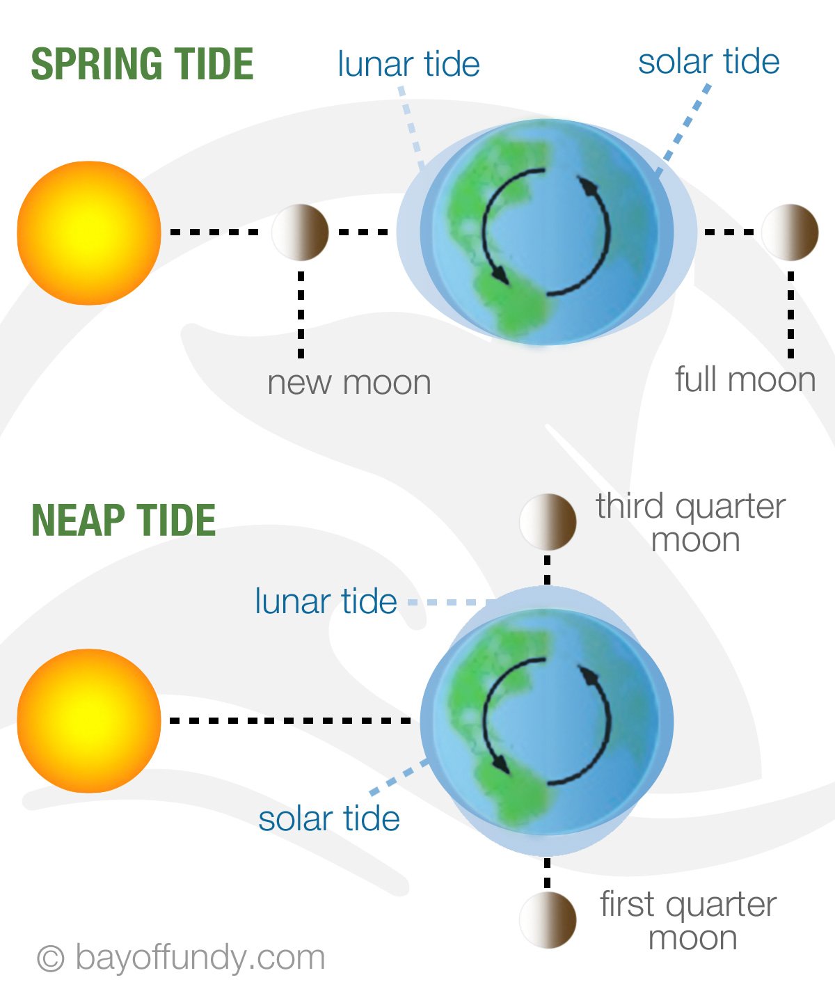
Twice a month when the pull of the moon and sun on the Earth are in alignment, the ocean tides are highest – these are known as “spring tides,” in the sense of bursting forth or jumping up, and occur during the full and new moon. Spring tides are bigger than “neap” tides, which occur during the other two major phases of the month, when the moon is either in its first or third quarter.
The highest spring tide of the year happens when the orbit and alignment of the sun and moon reinforce at their closest and furthest extremes from the Earth – this is what is colloquially being called a “king tide,” although this is not a scientific term. Often the highest tides in our oceans occur in June and December because of the influence of the sun on the Earth. However, the moon’s effect plays a crucial role as well and can result in the highest tides in some places being in October. Tides are a complex and fascinating topic. You can read a good explanation of the physics here.
Today’s highest tides become the new normal with climate change

Source: New Hampshire/Maine Realtors
Extreme high tides give us an excellent opportunity to raise awareness about the impacts of sea level rise on low-lying coastal areas and areas where land is subsiding. In many places, today’s highest tides will become common water levels within our lifetimes. A UCS infographic here explains how and why.
Roughly a third of the U.S. population lives in coastal counties and is especially vulnerable to rising seas and storm surge in low-lying areas. To visualize the direct impacts of a rising ocean on these communities, initiatives around the country have been collecting photographs of extreme high tides. See some images here from New Hampshire, Florida, and New Jersey.
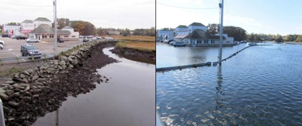
The Bratskellar Restaurant near Portsmouth in New Hampshire during the highest tide of the year in 2011. Low tide on the left, high tide on the right. Source: Jim Lee, New Hampshire/Maine Realtors
Climate projections show that if we continue on our current emissions pathway, by the end of the century what is now a rare water level may become typical. And we know local decision makers are already talking about how to protect communities from sea level rise by finding smart ways to lessen the risks.
But these king tides also can open up the more difficult conversations of whether we can simply adapt to the future that’s headed our way or if we need to “avoid the unmanageable” with stronger mitigation efforts. Another piece of the future story — which king tides may not capture — is the impacts that occur when any given coastal storm rides in on top of these increased sea levels.
Repository of images helps planners with adaptation
Photographs of extreme high tides are a valuable repository for planners and managers in all levels of government. The images highlight places that will become increasingly vulnerable to flooding, higher storm surges, eroding shorelines, and saltwater intrusion under ongoing sea level rise.
The Environmental Protection Agency (EPA) is helping coastal managers develop adaptation plans as part of their Climate Ready Estuaries program, and is supported by the State Department. Photographs from the king tides initiative form an important part of this work. If you are interested in learning more about high tide photography globally, see the Witness King Tides project by Green Cross in Australia, the country where chasing king tides began in 2009.