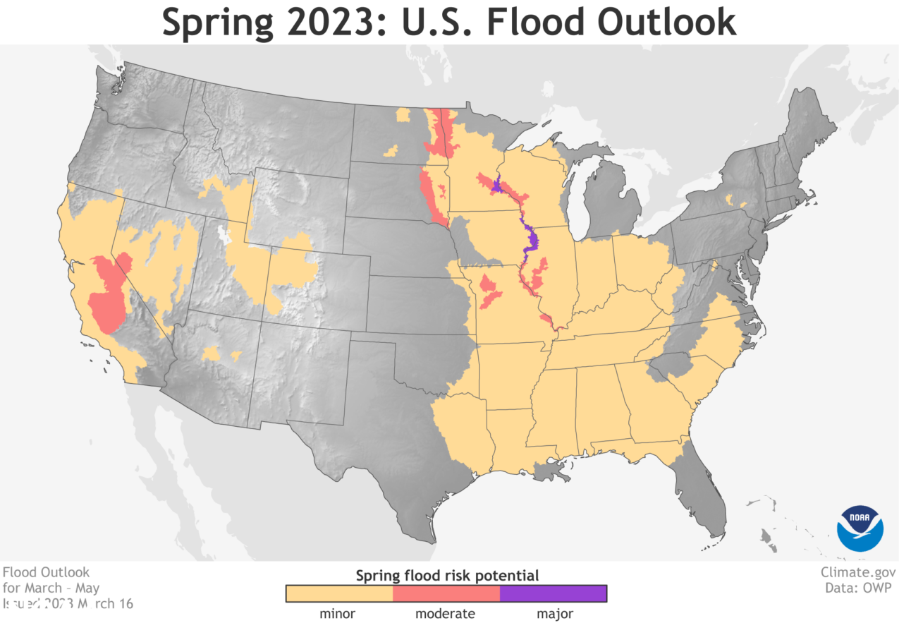
For many of us, spring can’t come soon enough–birds singing, flowers blooming, and longer days are ahead. However, getting ready for spring means thinking about what the risk of flooding might be in our region. Today the National Oceanic and Atmospheric Administration (NOAA) announced the US Spring Outlook. Here are a few key takeaways.
First the good news: The “abnormally” wet winter has improved the extensive drought conditions across the country and helped to replenish many of the reservoirs in California, the Great Basin and the Colorado River Basin. But drought conditions will not disappear altogether. Follow this link for more specific details on regional drought conditions.
Here’s the not so good news: NOAA’s data indicate a risk of flooding this spring for the eastern portion of the country, amounting to roughly 44 percent of the nation. And certain regions will have a higher risk of flooding, including the Sierra Nevada area, portions of the Missouri River Basin, and parts of the Upper Mississippi River Basin.
Of particular concern are the sections of the Upper Mississippi region where NOAA has flagged a heightened risk of major flooding.

Climate change is exacerbating flood risk and damages
NOAA’s administrator, Rick Spinrad, said the climate change connection is “driving both wet and dry extremes,” as illustrated by the agency’s observations and data. Human-driven climate change is fueling more extreme weather and climate change-related disasters. With warmer temperatures, we see increased evaporation rates and higher levels of water vapor or moisture in the air, so when it rains, it pours. According to the U.S. Global Change Research Program’s (USGCRP) Fourth National Climate Assessment, annual average precipitation across the country has increased 4 percent since the beginning of the last century. However, since 1958, the amount of rain falling in the heaviest events has increased in all regions in the lower 48 states, with the largest percentage increases in the Northeast (55 percent) and in the Midwest (42 percent). These trends are projected to continue with a warming climate.
More rainfall doesn’t always translate to more flooding. It depends on both natural factors and the built infrastructure. Flooding in the natural landscape brings multiple benefits, including replenishment of rivers, groundwater, and the surrounding ecosystems. With reduced natural areas, more hard surfaces from buildings to parking lots, and such infrastructure as dams and levees, however, we’ve increased exposure and vulnerability to rainfall and storms.
With the increase in population, risky development practices and climate change, it should come as no surprise to decisionmakers that we’re seeing a rising cost of extreme weather and climate change-related disasters since 1980, when record keeping began. NOAA’s National Centers for Environmental Information (NCEI) ranked 2022 as the third costliest year for billion-dollar disasters.
In July 2022, heavy rainfall in Kentucky and Missouri triggered devastating flash flooding that caused $1.5 billion in damages and 42 deaths. The National Weather Service estimated peak rainfall totals of 14 to 16 inches over a three-day period and said they were “historically unheard of.”
But more than dollars and cents, extreme flooding and other climate change-related impacts are hitting the most socially vulnerable groups the hardest. Compounding the multiple challenges communities face to prepare before the next flood is the lack of flood risk awareness. A recent study by First Street Foundation utilized the latest science on riverine, rainfall, tidal and storm surge flooding and found that 5.9 million properties are either not included in the Federal Emergency Management Agency’s (FEMA) Flood Insurance Rate Maps or, if they are, the maps do not adequately reflect the actual flood risk.
Congress must lead by example to reduce flood risk
With each flood disaster, we can’t escape the fact that we simply aren’t prepared. Each level of government—local, state, tribal and federal—has a role to play in reducing flood risk and helping communities become more prepared. But federal leadership is needed to help incentivize and support local, state and tribal actions.
Congress should enact key reforms to the National Flood Insurance Program (NFIP), which by law must be reauthorized by September 30. After 25 short-term reauthorizations, it’s time for Congress to stop kicking the can down the road.
While the flood insurance program needs many reforms, there are a few critical policies that could make a big difference in reducing flood risk and should have bipartisan support.
- First, Congress must include robust resources to fund FEMA’s flood mapping program. The Association of State Floodplain Managers studied flood mapping needs and found that FEMA’s flood maps cover only one-third of the streams across the nation. But updates to FEMA’s mapping efforts also need to incorporate the latest science on climate change. To complete this critical work, the association estimates it will take roughly $1.8 billion.
- Second, after years of work by the National Academies and FEMA, Congress should fund and implement a flood insurance affordability program to ensure marginalized, low-income groups can have a financial lifeline to recover when a flood hits as well as resources to reduce their flood risks.
- Finally, Congress must enact flood risk disclosure policies so that homeowners and renters understand the current and future flood risk of their home and can make informed decisions on how best to prepare.
NOAA’s Spring Outlook calls on us to prepare for what look to be risky flood conditions from now through May. This forecast, along with the knowledge that floods are among the costliest disasters, must prompt Congress to reform and modernize how we manage flood risk across the nation. Time is of the essence for Congress to do this essential work to help communities, especially marginalized and low-resourced communities, prepare for the next deluge.

