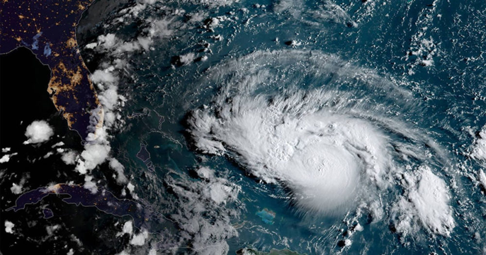

Hurricane Dorian is slowly churning its way toward Florida’s Atlantic coast and is expected to make landfall on Monday or Tuesday as a potentially catastrophic Category 4 storm. Even as our hearts hope for the safety of the people of Florida, we scientists are often asked about the connection between hurricanes and climate change. And next Wednesday, presidential candidates will also be on the hook to answer some hard questions about climate change—and how we must respond as a nation.
So for all the presidential candidates—and for everybody in America who cares about our future climate—this post lays out what we know about those connections and explains how Dorian fits into the picture.

Does climate change affect hurricanes?
YES. Both simple physics and studies of recent hurricanes indicate that our warming climate amplifies the strength of hurricanes in three primary ways:
1. Warmer water provides more fuel for hurricanes
The oceans have taken in nearly all of the excess heat created by global warming, absorbing 93 percent of the increase from 1971-2010. As a result, since 1970, sea surface temperatures worldwide have warmed by about an average of 0.13°F per decade. The warming has been even more pronounced in the Atlantic Ocean, which has warmed by about 0.5°F per decade since the 1970s.
The latest science suggests that warming has a minimal effect on the frequency of hurricanes. But in some ocean basins, rising ocean temperatures have been linked to a strengthening of hurricanes. In other words, climate change makes it more likely for hurricanes to reach Categories 4 and 5—and more likely for catastrophic damage to occur.
Warmer conditions are also making it more likely that hurricanes will undergo rapid intensification. A study published earlier this year concluded that the rapid intensification we’ve seen with recent hurricanes—including Harvey in 2017 and Michael in 2018—cannot be explained by natural variability and that climate change was responsible for the unusual rapid intensification patterns. Overall, the percentage of Atlantic hurricanes undergoing rapid intensification has tripled since the early 1980s.
How do these factors relate to Hurricane Dorian? As it makes its way toward Florida, Dorian will be passing over water that is about 1°F (0.5°C) warmer than usual. Its slow path over these warm waters means that Dorian has the potential to accumulate more energy, which translates to more potential rainfall and stronger winds, the latter of which can increase the potential magnitude of the storm’s surge and resulting inland flooding. Warmer waters also create the possibility of rapid intensification.
2. Rising seas lead to higher, more extensive storm surge
Sea level rise, a consequence of global warming, makes the storm surge associated with hurricanes higher and therefore more extensive. As one example, Hurricane Sandy hit New York City in 2012 and caused widespread flooding. After the storm, researchers found that sea level rise was responsible for an additional $2 billion in damages.
Because of the new moon this weekend, coastal locations in Florida and elsewhere are already expecting king tides, when high tides are higher than usual. At a tide gauge in St. Augustine, for example, the predicted high tides through the middle of next week are on the order of a foot above normal for several tide cycles in a row even before factoring in storm surge. If the storm’s surge before, during, or after coincides with one of these above average high tide cycles, that would amplify the depth and reach of Dorian’s surge.

Because of the new moon, high tides will be running higher than normal through early next week. Tide predictions shown here are for St. Augustine, Florida.
On the other hand, the continental shelf drops off steeply off the Atlantic Coast of Florida. Those deep waters offshore could serve to dampen the storm surge Dorian brings with it. This is in contrast to hurricanes that affect the Gulf Coast of Florida or other Gulf States because the continental shelf in the Gulf of Mexico is broad and shallow.
3. Warmer air holds more moisture for rainfall
Warmer air can hold more water, which means that in a warming world there’s more potential for extremely heavy rainfall. One recent example of this was the record-breaking rainfall—60 inches!—that fell during Hurricane Harvey in 2017. Studies of that event have shown that climate change made the storm’s rainfall about 15% heavier and three times as likely as it would have been without human-induced warming.
The forecast as of this afternoon shows much of Florida expecting six to ten inches of rainfall in the next week. The forecast also shows Georgia and the Carolinas receiving heavy rain.
It’s important to keep in mind that this rain is following on the heels of the wettest 12 months on record for the United States. In Florida, soil moisture levels are above normal right now, and about 25% of the streams and rivers around the state already have above-normal levels of streamflow. (Streamflow generally increases as the volume of water in a stream or river increases.) The heavy bout of rain that Dorian promises to deliver could overwhelm the streams and rivers that are already at high level and present major challenges in a state and region that already experience extreme drainage problems.
What does the future hold?
As the climate continues to warm, the strength of tropical cyclones (including hurricanes in the North Atlantic) is projected to rise. The projected increase in intense hurricanes is substantial—a doubling or more in the frequency of category 4 and 5 storms by the end of the century—with the western North Atlantic experiencing the largest increase.
When scientists put the pieces together, they project that in general, hurricanes will become more intense in a warming world, with higher wind speeds and greater levels of precipitation, much like we’ve seen recently with Hurricanes Harvey, Michael, and Florence.
We also know, though, that the destructive potential of hurricanes involves not just the physics of hurricanes and climate change, but also what lies in their paths. Growing population density along our coasts translates to more people, more homes, and more value in the path of any given hurricane.

Extreme weather exacts an emotional as well as physical toll on affected communities. Photo: U.S. Air Force/Staff Sgt. James L. Harper Jr.
Once the storm passes, what do we need to do?
The science tells us that in a warmer climate we can expect to see more strong hurricanes like the ones we have experienced in recent years. As we look to 2020 and beyond, we will need to be building the resilience of our communities and infrastructure to strong hurricanes like Dorian. Ramping up existing programs like FEMA’s pre-disaster mitigation grant program and ensuring that FEMA’s flood zone maps are incorporating the latest sea level rise science are just two of many needed solutions.
Building our long-term resilience to future storms will be more achievable if we also start working now to aggressively reduce carbon emissions in the US and globally. Hurricanes are a natural part of Earth’s climate. But the more we can limit future warming, the better the odds of avoiding unnaturally destructive storms.
For more science-based information, check out UCS’s website on Hurricanes and Climate Change.